| Toucountouna | |
|---|---|
| Commune, arrondissement and town | |
 | |
| Coordinates: 10°29′55″N 1°22′32″E / 10.49861°N 1.37556°E / 10.49861; 1.37556 | |
| Country | |
| Department | Atakora Department |
| Area | |
| • Total | 600 sq mi (1,600 km) |
| Population | |
| • Total | 39,779 |
| Time zone | UTC+1 (WAT) |
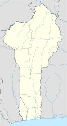
Toucountouna [tu.kun.tu.na] is a town, arrondissement and commune in the Atakora Department of north-western Benin. The commune covers an area of 1600 square kilometres and as of 2013 had a population of 39,779 people.
See also
References
- "Toucountouna". Atlas Monographique des Communes du Benin. Retrieved January 5, 2010.
- "Communes of Benin". Statoids. Retrieved January 5, 2010.
10°29′55″N 1°22′32″E / 10.49861°N 1.37556°E / 10.49861; 1.37556
| Boukoumbè |  | |
|---|---|---|
| Cobly | ||
| Kérou | ||
| Kouandé | ||
| Matéri | ||
| Natitingou | ||
| Péhunco | ||
| Tanguiéta | ||
| Toucountouna | ||
This Atakora Department location article is a stub. You can help Misplaced Pages by expanding it. |
