Misplaced Pages

Umling Gewog

Article snapshot taken from[REDACTED] with creative commons attribution-sharealike license. Give it a read and then ask your questions in the chat. We can research this topic together.
Gewog in Sarpang District, Bhutan
Umling Gewog ཨུམ་གླིང་
Gewog
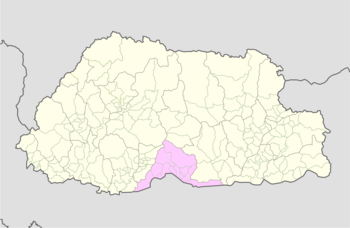
Location of Umling Gewog
Country Bhutan
DistrictSarpang District
Area
 • Total122 km (47 sq mi)
Elevation190−400 m (−1,120 ft)
Population
 • Total3,129
Time zoneUTC+6 (BTT)

Umling Gewog (Dzongkha: ཨུམ་གླིང་) is a gewog (village block) of Sarpang District, Bhutan.

Umling Gewog is situated in the central Southern foothills of Sarpang Dzongkhag, bordering Assam, India, in the South, and Chuzagang Gewog in the West, Tareythang Gewog in the East and Zhemgang Dzongkhag in the North.

Its total geographical area is approximately 122 km (47 sq mi), of which 1,480 acres (600 ha) is arable land. It has undulated terrain with an elevation ranging from 190 to 400 m (620 to 1,310 ft) above sea level. It has warm and humid climatic condition in winter and hot and rainy climatic conditions in summer.

It is approximately 33 km (21 mi) from the Dungkhag headquarters (Gelephu) and is connected with the farm road which is inaccessible in the monsoon season due to heavy downpour. It has a total population of 3129 with almost 100 percent of the people dependent upon agriculture.

Arecanut and ginger are grown as principal cash crop while paddy and maize are cultivated as main crop by the farmers. Beside farmers also rear domestic animals like cows, oxen, goats, sheep, etc. which ultimately add to their livelihood.

Until 2011 local government election, the Gewog had eight Chiwogs, namely: Chhuborthang, Daangling, Doongmin, Gaden, Lingar, Rijoog, Tashithang and Thongjazor and was merged into five Chiwogs, namely: Daangling, Doongmin, Gaden, Rijoog and Tashithang after the first LG election. The Geog is administratively headed by Gelephu Dungkhag and subsequently by Sarpang Dzongkhag.

References

  1. "Chiwogs in Sarpang" (PDF). Election Commission, Government of Bhutan. 2011. Archived from the original (PDF) on 2011-10-02. Retrieved 2011-07-28.
  2. "-". Royal Government of Bhutan. Retrieved December 12, 2010.
  3. RNR-SCS. (2013). Bhutan RNR Statistics 2012. Thimphu: Ministry of Agriculture and Forest
  4. "Chiwogs in Sarpang" (PDF). Election Commission, Government of Bhutan. 2011. Archived from the original (PDF) on 2011-10-02. Retrieved 2011-07-28.
Village groups (gewogs) of Bhutan
Central
Bhutan Zone
Dagana District
Dorona
Drujegang
Gesarling
Goshi
Karmaling
Karna
Khebisa
Lajab
Lhamoy Zingkha
Nichula
Tashiding
Tsangkha
Tsendagang
Tseza
Gasa District
Khamaed
Khatoed
Laya
Lunana
Punakha District
Barp
Chhubu
Dzomi
Goenshari
Guma
Kabjisa
Lingmukha
Shenga Bjime
Talog
Toepisa
Towang
Tsirang District
Barshong
Dunglegang
Gosarling
Kilkhorthang
Mendrelgang
Patshaling
Phuentenchhu
Rangthangling
Semjong
Sergithang
Tsholingkhar
Tsirangtoe
Wangdue Phodrang District
Athang
Bjendag
Dangchu
Darkar
Gangteng
Gasetsho Gom
Gasetsho Om
Kazhi
Nahi
Nyisho
Phangyuel
Phobji
Ruepisa
Sephu
Thedtsho
Bhutan
Southern
Bhutan Zone
Bumthang District
Chhume
Choekor
Tang
Ura
Sarpang District
Chhuzagang
Chhudzom
Dekiling
Gakiling
Gelephu
Jigmechhoeling
Samtenling
Senghe
Serzhong
Shompangkha
Tareythang
Umling
Trongsa District
Dragteng
Korphu
Langthil
Nubi
Tangsibji
Zhemgang District
Bardo
Bjoka
Goshing
Nangkor
Ngangla
Phangkhar
Shingkhar
Trong
Western
Bhutan Zone
Chukha District
Bjacho
Bongo
Chapcha
Dala
Dungna
Geling
Getena
Logchina
Metakha
Phuentsholing
Sampheling
Haa District
Bji
Gakiling
Katsho
Sama
Sangbay
Uesu
Paro District
Dokar
Dopshari
Doteng
Hungrel
Lamgong
Lungnyi
Naja
Shapa
Tsento
Wangchang
Samtse District
Dungtoe
Dophoogchen
Denchukha
Namgaychhoeling
Norbugang
Norgaygang
Pemaling
Phuentshogpelri
Samtse
Sangngagchhoeling
Tading
Tashicholing
Tendu
Ugentse
Yoeseltse
Thimphu District
Chang
Darkarla
Genye
Kawang
Lingzhi
Mewang
Naro
Soe
Eastern
Bhutan Zone
Lhuntse District
Gangzur
Jaray
Khoma
Kurtoe
Menbi
Metsho
Minjay
Tsenkhar
Mongar District
Balam
Chaskhar
Chhali
Drametse
Drepung
Gongdue
Jurmey
Kengkhar
Mongar
Narang
Ngatshang
Saling
Shermuhoong
Silambi
Thangrong
Tsakaling
Tsamang
Pemagatshel District
Chimoong
Choekhorling
Chongshing
Dechenling
Dungmaed
Khar
Nanong
Norbugang
Shumar
Yurung
Zobel
Samdrup Jongkhar District
Dewathang
Gomdar
Langchenphu
Lauri
Martshala
Orong
Pemathang
Phuntshothang
Samrang
Serthi
Wangphu
Trashigang District
Bartsham
Bidung
Kanglung
Kangpar
Khaling
Lumang
Merag
Phongmed
Radi
Sakteng
Samkhar
Shongphoog
Thrimshing
Uzorong
Yangnyer
Trashiyangtse District
Bumdeling
Jamkhar
Khamdang
Ramjar
Toetsho
Tomzhangsa
Yangtse
Yalang
Former Gewogs
Dagana District
Deorali
Chukha District
Bhulajhora
Pemagatshel District
Nganglam
Samtse District
Chargharey
Chengmari
Ghumauney
Mayona
Nainital
Pagli
Sarpang District
Bhur
Doban
Hilley
Taklai
Thimphu District
Bapbi
Tsirang District
Beteni
Chanautey
Gairigaun
Tshokhana
Tsirang Dangra
Samdrup Jongkhar District
Bakuli
Hastinapur


Stub icon

This Bhutan location article is a stub. You can help Misplaced Pages by expanding it.

Categories:
Umling Gewog Add topic