| Ushana Үшана | |
|---|---|
| Village | |
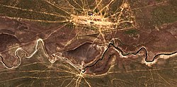
 The Kaldygaity meandering westwards south of Ushana Sentinel-2 image The Kaldygaity meandering westwards south of Ushana Sentinel-2 image | |
 | |
| Coordinates: 49°27′07″N 52°57′14″E / 49.45194°N 52.95389°E / 49.45194; 52.95389 | |
| Country | Kazakhstan |
| Regione | West Kazakhstan Region |
| District | Karatobe District |
| Rural District | Sulykol Rural District |
| Population | |
| • Total | 696 |
| Time zone | UTC+5 (UTC + 5) |
Ushana (Kazakh: Үшана), until 1990 known as "Batpakkol", is a village in the Karatobe District, West Kazakhstan Region, Kazakhstan. It is part of the Sulykol Rural District (KATO code - 275049500). Population: 696 (2009 Census results); 784 (1999 Census results).
Geography
Ushana is located by the Kaldygaity river, east of Tolen village. It lies 47 kilometers (29 mi) southwest of Karatobe.
References
- ^ "Население Республики Казахстан" [Population of the Republic of Kazakhstan] (in Russian). Департамент социальной и демографической статистики. Retrieved 8 December 2013.
- "M-39 Topographic Chart (in Russian)". Retrieved 11 February 2023.
- Google Earth.
| West Kazakhstan Region | ||
|---|---|---|
| Capital: Oral | ||
| Districts |  | |
| Major cities and towns | ||
This Kazakhstan location article is a stub. You can help Misplaced Pages by expanding it. |