| Vomperbach | |
|---|---|
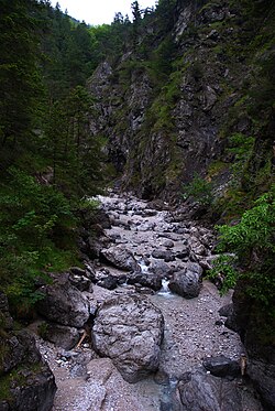
 The Vomperbach in the Vomper Loch [de; fr] The Vomperbach in the Vomper Loch [de; fr] | |
| Location | |
| Country | Austria |
| State | Tyrol |
| Physical characteristics | |
| Source | |
| • location | Karwendel mountain range |
| Mouth | |
| • location | Between Vomp and Terfens into the Inn |
| • coordinates | 47°19′27″N 11°40′45″E / 47.3243°N 11.6791°E / 47.3243; 11.6791 |
| Length | 17.2 km (10.7 mi) |
| Basin features | |
| Progression | Inn→ Danube→ Black Sea |
The Vomperbach is a river of Tyrol, Austria, a tributary of the Inn.
The Vomperbach rises in the Karwendel mountain range, close to the source of the Isar and flows first from west to east. In the Vomper Loch [de; fr], a tributary valley of the Inn that is partly a ravine, the Vomperbach changes its course southward and finally passes as boundary between the villages of Vomp and Terfens, where it discharges into the Inn. It has a length of 17 kilometres (11 mi).
Water quality
In its upper course in the Vomper Loch, the river is partly covered by detrital, therefore almost invisible and a water quality cannot be measured. Below until its mouth the water quality remains constantly grade A and provides the villages with drinking water.
References
This article related to a river in Austria is a stub. You can help Misplaced Pages by expanding it. |
This Tyrol location article is a stub. You can help Misplaced Pages by expanding it. |