Hamlet in Alberta, Canada
| Watino | |
|---|---|
| Hamlet | |
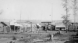
 Watino, circa 1915 Watino, circa 1915 | |
  | |
| Coordinates: 55°43′09″N 117°37′02″W / 55.71917°N 117.61722°W / 55.71917; -117.61722 | |
| Country | Canada |
| Province | Alberta |
| Region | Northern Alberta |
| Census division | 19 |
| Municipal district | Birch Hills County |
| Government | |
| • Type | Unincorporated |
| • Governing body | Birch Hills County Council |
| Population | |
| • Total | 22 |
| Time zone | UTC−07:00 (MST) |
| • Summer (DST) | UTC−06:00 (MDT) |
| Area code(s) | 780, 587, 825 |
Watino is a hamlet in northern Alberta, Canada within Birch Hills County. It is located on Highway 49, approximately 96 kilometres (60 mi) northeast of Grande Prairie, and has an elevation of 385 meters (1,263 ft).
History
Watino was established on the banks of the Smoky River, downstream from its confluence with the Little Smoky River. The name Watino is derived from the Cree word "Wa-ye-te-naw", meaning "valley".
When the Edmonton, Dunvegan and British Columbia Railway began to construct a railway bridge over the Smoky River in 1915, two temporary hamlets sprang up on either side of the river. On the east bank was the main railway camp, called Pruden's Crossing, and on the west, connected by a small cable ferry, was the hamlet of Smoky River, or "Old Smoky".
The railway bridge was erected in 1916, and a railway siding situated on the west bank. It was here that Carl Donis opened the first post office, named Prudens Crossing, in 1917. The community was renamed Watino in 1921, and the post office name changed to the same in November 1925 .
Eventually Watino contained a school, two grocery stores, two hardware stores, post office, three machine agencies, garage, grain elevator, restaurant, pool hall, community hall, and skating rink . There was also a railway station, a pump station, and coal dock for the steam trains, and stockyards on the railway, from which Egg Lake Ranch shipped 13 carloads of cattle to Chicago in 1920. The railway was the main mode of transportation until 1938, when the bush trail into the community was replaced by a highway and a connecting ferry over the Smoky River. In 1950, the establishment of the Park Brothers sawmill and planer made Watino boom.
Watino declined in the 1970s and 1980s. In 1972, the Smoky River flooded, washing away much farmland in the valley, and in 1975 the grain elevator was removed. In 1987 another flood caused heavy damage to the east and west sides of the railroad bridge and forcing the closure of the CNR train system through Watino.
Demographics
| Year | Pop. | ±% |
|---|---|---|
| 1941 | 56 | — |
| 1951 | 126 | +125.0% |
| 1956 | 150 | +19.0% |
| 1961 | 93 | −38.0% |
| 1966 | 60 | −35.5% |
| 1971 | 68 | +13.3% |
| 1976 | 66 | −2.9% |
| 1981 | 54 | −18.2% |
| 1986 | 47 | −13.0% |
| 1991 | 22 | −53.2% |
| Source: Statistics Canada | ||
Watino recorded a population of 22 in the 1991 Census of Population conducted by Statistics Canada.
See also
References
- ^ 91 Census (PDF). Population and Dwelling Counts. Vol. Unincorporated Places. Ottawa: Statistics Canada. 1993. Retrieved September 26, 2024.
- "Specialized and Rural Municipalities and Their Communities" (PDF). Alberta Municipal Affairs. June 3, 2024. Retrieved June 14, 2024.
- ^ Smoky Peace Triangle. Eaglesham History Book Committee. 1991. pp. 39–47, 123.
- ^ Canada, Library and Archives (July 5, 2013). "Item". Library and Archives Canada. Retrieved May 25, 2015.
- Ninth Census of Canada, 1951 (PDF). Vol. SP-7 (Population: Unincorporated villages and hamlets). Dominion Bureau of Statistics. March 31, 1954. Retrieved September 22, 2024.
- Census of Canada, 1956 (PDF). Vol. Population of unincorporated villages and settlements. Dominion Bureau of Statistics. October 25, 1957. Retrieved September 23, 2024.
- 1961 Census of Canada: Population (PDF). Series SP: Unincorporated Villages. Vol. Bulletin SP—4. Ottawa: Dominion Bureau of Statistics. April 18, 1963. Retrieved September 25, 2024.
- Census of Canada 1966: Population (PDF). Special Bulletin: Unincorporated Places. Vol. Bulletin S–3. Ottawa: Dominion Bureau of Statistics. 1968. Retrieved September 25, 2024.
- 1971 Census of Canada: Population (PDF). Special Bulletin: Unincorporated Settlements. Vol. Bulletin SP—1. Ottawa: Statistics Canada. 1973. Retrieved September 25, 2024.
- "Geographical Identification and Population for Unincorporated Places of 25 persons and over, 1971 and 1976". 1976 Census of Canada (PDF). Supplementary Bulletins: Geographic and Demographic (Population of Unincorporated Places—Canada). Vol. Bulletin 8SG.1. Ottawa: Statistics Canada. 1978. Retrieved September 26, 2024.
- 1981 Census of Canada (PDF). Place name reference list. Vol. Western provinces and the Territories. Ottawa: Statistics Canada. 1983. Retrieved September 26, 2024.
- 1986 Census of Canada (PDF). Population. Vol. Unincorporated Places. Ottawa: Statistics Canada. 1988. Retrieved September 26, 2024.
This Northern Alberta location article is a stub. You can help Misplaced Pages by expanding it. |