Suburb of Sydney, New South Wales, Australia
| Willoughby East Sydney, New South Wales | |||||||||||||||
|---|---|---|---|---|---|---|---|---|---|---|---|---|---|---|---|
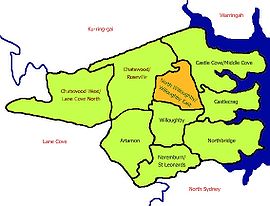
 Map of North Willoughby/Willoughby East Map of North Willoughby/Willoughby East | |||||||||||||||
| Population | 1,864 (2021 census) | ||||||||||||||
| Postcode(s) | 2068 | ||||||||||||||
| Location | 9 km (6 mi) north of Sydney CBD | ||||||||||||||
| LGA(s) | City of Willoughby | ||||||||||||||
| State electorate(s) | Willoughby | ||||||||||||||
| Federal division(s) | North Sydney | ||||||||||||||
| |||||||||||||||
Willoughby East is a suburb on the lower North Shore of Sydney, in the state of New South Wales, Australia. Willoughby East is located 9 kilometres north of the Sydney central business district, in the local government area of the City of Willoughby.
Population
In the 2021 Census, there were 1,864 people in Willoughby East. 73.1% of people were born in Australia and 81.0% of people spoke only English at home. The most common responses for religion were No Religion 38.0%, Catholic 31.5% and Anglican 13.1%.
Transport
A bus depot is located in Stan Street.
References
- ^ Australian Bureau of Statistics (28 June 2022). "Willoughby East (State Suburb)". 2021 Census QuickStats. Retrieved 20 October 2024.

33°47′56″S 151°12′22″E / 33.799°S 151.206°E / -33.799; 151.206
This article related to the geography of Sydney is a stub. You can help Misplaced Pages by expanding it. |