| Wzdów | |
|---|---|
| Village | |
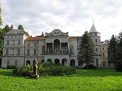
 Ostaszewski Palace Ostaszewski Palace | |
 | |
| Coordinates: 49°37′N 22°1′E / 49.617°N 22.017°E / 49.617; 22.017 | |
| Country | |
| Voivodeship | Subcarpathian |
| County | Brzozów |
| Gmina | Haczów |
| Population | 1,000 |
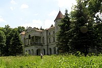
Wzdów is a village in the administrative district of Gmina Haczów, within Brzozów County, Subcarpathian Voivodeship, in south-eastern Poland. It lies approximately 10 kilometres (6 mi) south-east of Haczów, 9 km (6 mi) south of Brzozów, and 47 km (29 mi) south of the regional capital Rzeszów. The palace at Wzdów was the seat the Polish noble family of Ostoja-Ostaszewski. After the expropriation of landlords in Poland by the communist regime in 1944/1945, the palace fell into ruin.
References
- "Central Statistical Office (GUS) – TERYT (National Register of Territorial Land Apportionment Journal)" (in Polish). 2008-06-01.
External links
| Gmina Haczów | ||
|---|---|---|
| Seat | ||
| Other villages | ||
This Brzozów County location article is a stub. You can help Misplaced Pages by expanding it. |

