| Zemianske Kostoľany | |
|---|---|
| Village | |
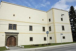
 Manor house in Zemianske Kostoľany Manor house in Zemianske Kostoľany | |
 | |
| Coordinates: 48°41′N 18°32′E / 48.683°N 18.533°E / 48.683; 18.533 | |
| Country | Slovakia |
| Region | Trenčín |
| District | Prievidza |
| First mentioned | 1331 |
| Area | |
| • Total | 12.77 km (4.93 sq mi) |
| Elevation | 232 m (761 ft) |
| Population | |
| • Total | 1,731 |
| Postal code | 972 43 |
| Area code | +421 46 |
| Car plate | PD |
Zemianske Kostoľany (Hungarian: Nemeskosztolány) is a village and municipality in Prievidza District in the Trenčín Region of western Slovakia.
History
In historical records the village was first mentioned in 1331.
Geography
The municipality lies at an altitude of 236 metres and covers an area of 12.772 km. It has a population of about 1,683 people.
Environment
Zemianske Kostoľany is the location of the Nováky Power Plant lignite fired power station. This power station was ranked by the European Environment Agency as the industrial facility that is causing the highest damage costs to health and the environment in Slovakia and the 18th worst in the entire European Union.
References
- "Počet obyvateľov podľa pohlavia - obce (ročne)". www.statistics.sk (in Slovak). Statistical Office of the Slovak Republic. 2022-03-31. Retrieved 2022-03-31.
- ^ "Hustota obyvateľstva - obce [om7014rr_ukaz: Rozloha (Štvorcový meter)]". www.statistics.sk (in Slovak). Statistical Office of the Slovak Republic. 2022-03-31. Retrieved 2022-03-31.
- ^ "Základná charakteristika". www.statistics.sk (in Slovak). Statistical Office of the Slovak Republic. 2015-04-17. Retrieved 2022-03-31.
- ^ "Hustota obyvateľstva - obce". www.statistics.sk (in Slovak). Statistical Office of the Slovak Republic. 2022-03-31. Retrieved 2022-03-31.
- "Industrial facilities causing the highest damage costs to health and the environment". European Environment Agency. Retrieved 25 November 2014.
This Trenčín District location article is a stub. You can help Misplaced Pages by expanding it. |