| Ziroobwe–Wobulenzi Road | |
|---|---|
| Route information | |
| Length | 16 mi (26 km) |
| History | Designation in 2016 (Expected) Completion in 2017 (Expected) |
| Major junctions | |
| East end | Ziroobwe |
| Major intersections | Bamunanika |
| West end | Wobulenzi |
| Location | |
| Country | Uganda |
| Highway system | |
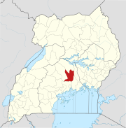
Ziroobwe–Wobulenzi Road is a road in Central Uganda, connecting the towns of Ziroobwe to Bamunanika and Wobulenzi, all in Luweero District.
Location
The road starts at Ziroobwe, approximately 51 kilometres (32 mi), north of Kampala, Uganda's capital and largest city. The road goes in a general westward direction through Bamunanika to end at Wobulenzi, on the Kampala–Gulu Highway, a total distance of approximately 25 kilometres (16 mi). The coordinates of the road near Bamunanika are 0°41'50.0"N, 32°36'20.0"E (Latitude:0.697222; Longitude:32.605556).
Overview
As far back as 2008, when the Gayaza–Ziroobwe Road was designated, the Ugandan government planned to tarmac the Ziroobwe–Wobulenzi Road. In June 2014, the Uganda National Roads Authority (UNRA) carried out an assessment to determine the individuals, families and businesses who will be displaced by the road works, with a view to compensate them. As at November 2014, the project was still in "preparation" stage.
Points of interest
The following points of interest also lie along or near the road:
1. The town of Ziroobwe, with estimated night-time population of 5,000 in 2012.
2. The Bamunanika Place of the Kabaka of Buganda is located in Bamunanika town.
3. Gayaza–Ziroobwe Road joins Ziroobwe–Wobulenzi Road in the middle of Ziroobwe town.
4. The town of Wobulenzi, located approximately 50 kilometres (31 mi) north of Kampala, along the Kampala–Gulu Highway.
5. The western end of this road at Wobulenzi lies approximately 3 kilometres (2 mi) south of Katikamu SDA Secondary School, a mixed boarding secondary school.
See also
References
- "Road Distance Between Kampala And Ziroobwe With Interactive Map" (Map). Google Maps. Retrieved 11 September 2022.
- "Ziroobwe–Wobulenzi Road" (Map). Google Maps. Retrieved 11 September 2022.
- "Location of Ziroobwe-Wobulenzi Road At Google Maps" (Map). Google Maps. Retrieved 13 August 2015.
- Baguma, Raymond (25 November 2008). "Gayaza Road Gets Tarmac". New Vision. Kampala. Retrieved 13 August 2015.
- Luwaga, Brian (11 February 2015). "Illegal Structures Emerge Along Wobulenzi-Ziroobwe Road Reserve Ahead of Compensation". Uganda Radio Network. Retrieved 13 August 2015.
- "UNRA To Begin Works On Sixteen Roads Next Year". Sunrise.ug. 4 November 2014. Retrieved 13 August 2015.
- Procopios Lumu (26 August 2012). "Ziroobwe: Akabuga k'Abalimi (Ziroobwe: The Small Town of Farmers)". Bukedde.co.ug (in Ganda). Retrieved 13 August 2015.
- "Road Distance Between Kampala, Uganda And Wobulenzi, Uganda" (Map). Google Maps. Retrieved 11 September 2022.
- "Road Distance Between Wobulenzi, Uganda And Katikamu Seventh Day Adventist Secondary School, Uganda" (Map). Google Maps. Retrieved 11 September 2022.
External links
| Capital: Luweero | ||
| Towns and villages |  | |
| Economy | ||
| Education |
| |
| Notable landmarks | ||
| Health | ||
| Transport |
| |
| Notable people | ||
00°41′50″N 32°36′20″E / 0.69722°N 32.60556°E / 0.69722; 32.60556
Categories: