| This article needs additional citations for verification. Please help improve this article by adding citations to reliable sources. Unsourced material may be challenged and removed. Find sources: "Aywaille" – news · newspapers · books · scholar · JSTOR (March 2013) (Learn how and when to remove this message) |
| Aywaille Aiwêye (Walloon) | |
|---|---|
| Municipality | |
 The Amblève in Aywaille The Amblève in Aywaille | |
|
| |
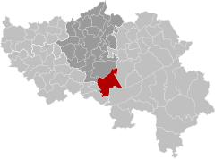
| Location of Aywaille | |
  | |
| Coordinates: 50°28′N 05°40′E / 50.467°N 5.667°E / 50.467; 5.667 | |
| Country | |
| Community | French Community |
| Region | Wallonia |
| Province | Liège |
| Arrondissement | Liège |
| Government | |
| • Mayor | Thierry Carpentier |
| Area | |
| • Total | 79.92 km (30.86 sq mi) |
| Population | |
| • Total | 12,405 |
| • Density | 160/km (400/sq mi) |
| Postal codes | 4920 |
| NIS code | 62009 |
| Area codes | 04 |
| Website | www.aywaille.be |
Aywaille (French pronunciation: [ɛwaj]; Walloon: Aiwêye) is a municipality of Wallonia located in the province of Liège, Belgium.
On 1 January 2012, Aywaille had a total population of 11,697. The total area is 80.04 km which gives a population density of 146 inhabitants per km. Its area consists of 45.7% of wooded and wild country, 29.9% of agricultural areas and 24.4% of built-up areas.
The inhabitants of Aywaille are called the "Aqualiens", from the Latin version of Aywaille "Aqualia loca", which means "area full of water" or "muddy land".
The municipality consists of the following districts: Aywaille, Ernonheid, Harzé, and Sougné-Remouchamps. They include many villages as Aywaille, Awan, Chambralles, Deigné, Ernonheid, Paradis, Houssonloge, Pouhon, Harzé, Havelange, Kin, Stoqueu, Martinrive, Nonceveux, Playe, Quarreux, Sedoz, Septroux, Sougné, Remouchamps, Ville-au-Bois.
Gallery
-
 Sougne-Remouchamps, railway bridge across the Rue de Trois Ponts
-
 Dieupart, church: l'église des Saints-Anges
-
 Deigné, church (l'église Saint-Joseph) in the village
-
 Martinrive, the Amblève
See also
References
- "Wettelijke Bevolking per gemeente op 1 januari 2018". Statbel. Retrieved 9 March 2019.
- "Commune d'Aywaille: coordonnées, bourgmestre, coalition, population et superficie". www.uvcw.be. Retrieved 2015-11-03.
- ^ "Commune d'Aywaille ..." www.aywaille.be. Retrieved 2015-11-03.
External links
- [REDACTED] Media related to Aywaille at Wikimedia Commons
| Places adjacent to Aywaille | ||||||||||||||||
|---|---|---|---|---|---|---|---|---|---|---|---|---|---|---|---|---|
| ||||||||||||||||
| Municipalities in the province of Liège, Wallonia | ||
|---|---|---|
| Huy |  | |
| Liège | ||
| Verviers | ||
| Waremme | ||
| ||