Misplaced Pages

K6 (mountain)

Article snapshot taken from[REDACTED] with creative commons attribution-sharealike license. Give it a read and then ask your questions in the chat. We can research this topic together.
Mountain in Pakistan
K6
کے 6
Baltistan Peak
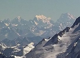
K6 (middle) and Saltoro Kangri (right) from the air in 2011
Highest point
Elevation7,282 m (23,891 ft)
Ranked 89th
Prominence1,962 m (6,437 ft)
ListingUltra
Coordinates35°25′12″N 76°33′00″E / 35.42000°N 76.55000°E / 35.42000; 76.55000
Geography
K6 is located in PakistanK6K6Location in Gilgit-BaltistanShow map of PakistanK6 is located in Gilgit BaltistanK6K6K6 (Gilgit Baltistan)Show map of Gilgit Baltistan
About OpenStreetMapsMaps: terms of use 45km
30miles Pakistan India ChinaGasherbrum V 48Gasherbrum VRimo III 47Rimo IIIApsarasas Kangri I 46Apsarasas Kangri IDiran 45DiranMuztagh Tower 44Muztagh TowerK6 43K6Yutmaru Sar 42Yutmaru SarBaintha Brakk 41Baintha BrakkCrown Peak 40Crown PeakBaltoro Kangri 39Baltoro KangriYazghil Dome South 38Yazghil Dome SouthSherpi Kangri 37Sherpi KangriRimo I, Rimo massif 36Rimo I, Rimo massifUltar, Ultar Peak, Ultar Sar 35Ultar, Ultar Peak, Ultar SarGhent Kangri 34Ghent KangriHaramosh Peak 33Haramosh PeakSkil Brum 32Skil BrumMomhil Sar 31Momhil SarSia Kangri 30Sia KangriK12 29K12Malubiting 28MalubitingTeram Kangri I 27Teram Kangri IYukshin Gardan Sar 26Yukshin Gardan SarPassu Sar 25Passu SarPumari Chhish 24Pumari ChhishSaser Kangri III 23Saser Kangri IIISaser Kangri II 22Saser Kangri IIMamostong Kangri K35 21Mamostong Kangri K35Skyang Kangri 20Skyang KangriTrivor Sar 19Trivor SarShispare or Shispare Sar 18Shispare or Shispare SarChogolisa 17ChogolisaSaser Kangri I, K22 16Saser Kangri I, K22Batura III 15Batura IIISaltoro Kangri, K10 14Saltoro Kangri, K10Kanjut Sar 13Kanjut SarBatura II 12Batura IIRakaposhi 11RakaposhiBatura Sar, Batura I 10Batura Sar, Batura IMasherbrum, K1 9Masherbrum, K1Kunyang Chhish (Kunyang Kish, Khunyang Chhish, Khinyang Chhish) 8Kunyang Chhish (Kunyang Kish, Khunyang Chhish, Khinyang Chhish)Distaghil Sar 7Distaghil SarGasherbrum IV, K3 6Gasherbrum IV, K3Gasherbrum III, K3a 5Gasherbrum III, K3aGasherbrum II, K4 4Gasherbrum II, K4Broad Peak 3Broad Peak Gasherbrum I, K5 2Gasherbrum I, K5 K2 1K2  The major peaks in Karakoram are rank identified by height.

Legend:
1:K2,  2:Gasherbrum I, K5,  3:Broad Peak,  4:Gasherbrum II, K4,  5:Gasherbrum III, K3a,  6:Gasherbrum IV, K3,  7:Distaghil Sar,  8:Kunyang Chhish,  9:Masherbrum, K1,  10:Batura Sar, Batura I,  11:Rakaposhi,  12:Batura II,  13:Kanjut Sar,  14:Saltoro Kangri, K10,  15:Batura III,  16: Saser Kangri I, K22,  17:Chogolisa,  18:Shispare,  19:Trivor Sar,  20:Skyang Kangri,  21:Mamostong Kangri, K35,  22:Saser Kangri II,  23:Saser Kangri III,  24:Pumari Chhish,  25:Passu Sar,  26:Yukshin Gardan Sar,  27:Teram Kangri I,  28:Malubiting,  29:K12,  30:Sia Kangri,  31:Momhil Sar,  32:Skil Brum,  33:Haramosh Peak,  34:Ghent Kangri,  35:Ultar Sar,  36:Rimo massif,  37:Sherpi Kangri,  38:Yazghil Dome South,  39:Baltoro Kangri,  40:Crown Peak,  41:Baintha Brakk,  42:Yutmaru Sar,  43:K6,  44:Muztagh Tower,  45:Diran,  46:Apsarasas Kangri I,  47:Rimo III,  48:Gasherbrum V

 
Location in Gilgit-Baltistan
LocationGilgit-Baltistan, Pakistan-controlled Kashmir
Parent rangeMasherbrum Mountains, Karakoram
Climbing
First ascent1970 by von der Hecken, G. Haberl, E. Koblmüller, G. Pressl
Easiest routeglacier/snow/ice climb
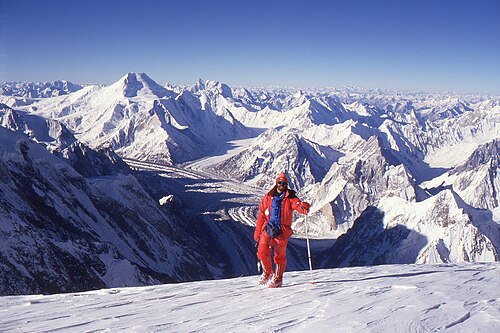
A climber stands in front of a vista of snow-covered mountains Chogolisa K6 A climber stands in front of a vista of snow-covered mountains K6 is shown in the background of this photo, 21.7 km (13.5 miles) from Chogolisa. At the foot of Chogolisa is Vigne Glacier.
K6
Simplified Chinese巴爾蒂斯坦峰
(K6峰)
Transcriptions

Surveyed as K6 (Urdu: کے 6), but also known as Baltistan Peak, it is a notable peak of the Masherbrum Mountains, a subrange of the Karakoram mountain range in the Gilgit Baltistan region of Pakistan. Despite being much lower than adjoining mountains, the Eight-thousanders and high 7000m peaks such as Masherbrum, K6 has huge, steep faces, and great relief above the nearby valleys.

Location

K6 is the highest peak in the area surrounding the Charakusa Glacier, a region which has seen renewed climbing interest in recent years. This glacier lies at the head of the Hushe Valley, which in turn leads to the Shyok River and thence to the Indus River. The Charakusa gives access to the north side of K6; to the southwest of the peak is the small Nangmah (or "Nangpah") Glacier, and to the east is the larger Kaberi Glacier and the Kaberi River valley.

History

The first ascent of K6 was in 1970, by an Austrian party, which was led by Eduard Koblmueller and included Gerhard Haberl, Christian von der Hecken and Gerd Pressl via the Southeast Ridge from the Nangmah Glacier. The expedition had originally planned to climb Malubiting but the Pakistan government withdrew this permission after the team arrived in the country. K6 was allotted to the team instead.

The Himalayan Index lists three additional attempts, but no additional ascents, on K6.

Notes

  1. The mountain is located on the western side of the Line of Control between India and Pakistan.

References

  1. ^ "High Asia I: The Karakoram, Pakistan Himalaya and India Himalaya (north of Nepal)". Peaklist.org. Retrieved 2014-05-27.
  2. Koblmueller, Eduard (1971). "The ascent of K6" (PDF). Alpine Journal. Translated by Bowman, E. London, England: Alpine Club: 149–155. Retrieved 2019-05-24.
  3. Koblmueller, Eduard (1971). "Asia, Pakistan, K6". Climbs And Expeditions. American Alpine Journal. American Alpine Club. Retrieved 2019-05-24.
  4. Himalayan Index
  • Neate, Jill (1990). High Asia: An Illustrated History of the 7000 Metre Peaks. Mountaineers Books. ISBN 978-0-89886-238-6.
  • Andy Fanshawe and Stephen Venables, Himalaya Alpine-Style, Hodder and Stoughton, 1995.
  • Himalayan Index
Stub icon

This Gilgit-Baltistan location article is a stub. You can help Misplaced Pages by expanding it.

Stub icon

This Pakistan location article is a stub. You can help Misplaced Pages by expanding it.

Categories:
K6 (mountain) Add topic