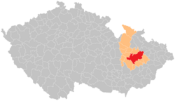
| Administrative district of the municipality with extended powers of Olomouc Správní obvod obce s rozšířenou působností Olomouc | |
|---|---|
| Administrative district of municipality with extended powers | |
 Location in the Olomouc Region within the Czech Republic Location in the Olomouc Region within the Czech Republic | |
| Coordinates: 49°36′N 17°18′E / 49.600°N 17.300°E / 49.600; 17.300 | |
| Country | |
| Region | Olomouc |
| District | Olomouc |
| Municipality with extended powers | Olomouc |
| Area | |
| • Total | 816.97 km (315.43 sq mi) |
| Population | |
| • Total | 168,674 |
| • Density | 210/km (530/sq mi) |
| Time zone | UTC+1 (CET) |
| • Summer (DST) | UTC+2 (CEST) |
| Municipalities | 45 |
| * Cities and towns | 3 |
| * Market towns | 3 |
The administrative district of the municipality with extended powers of Olomouc (abbreviated AD MEP Olomouc; Czech: Správní obvod obce s rozšířenou působností Olomouc, SO ORP Olomouc) is an administrative district of municipality with extended powers in Olomouc District in the Olomouc Region of the Czech Republic. It has existed since 1 January 2003, when the districts were replaced administratively. It includes 45 municipalities along with the Libavá Military Training Area which have a combined population of about 169,000.
Municipalities
Cities and towns are in bold, and market towns are in italics.
| Municipality | Population | Area (km | Density |
|---|---|---|---|
| Bělkovice-Lašťany | 2,270 | 15.30 | 148 |
| Blatec | 658 | 6.58 | 100 |
| Bohuňovice | 2,531 | 12.57 | 201 |
| Bukovany | 707 | 3.16 | 223 |
| Bystročice | 895 | 8.01 | 111 |
| Bystrovany | 1,002 | 3.51 | 285 |
| Daskabát | 620 | 5.83 | 106 |
| Dolany | 2,942 | 23.77 | 123 |
| Doloplazy | 1,340 | 8.04 | 166 |
| Drahanovice | 1,845 | 13.53 | 136 |
| Dub nad Moravou | 1,629 | 15.23 | 106 |
| Grygov | 1,519 | 12.72 | 119 |
| Hlubočky | 4,202 | 22.31 | 188 |
| Hlušovice | 1,095 | 4.25 | 257 |
| Hněvotín | 1,920 | 11.73 | 163 |
| Horka nad Moravou | 2,685 | 11.93 | 225 |
| Charváty | 945 | 8.88 | 106 |
| Kozlov | 272 | 45.76 | 5.9 |
| Kožušany-Tážaly | 880 | 6.27 | 140 |
| Krčmaň | 501 | 4.98 | 100 |
| Křelov-Břuchotín | 1,954 | 7.91 | 247 |
| Libavá | 0 | 235.49 | 0 |
| Liboš | 619 | 4.30 | 143 |
| Loučany | 621 | 4.98 | 124 |
| Luběnice | 500 | 2.76 | 181 |
| Lutín | 3,234 | 8.20 | 394 |
| Majetín | 1,184 | 9.50 | 124 |
| Mrsklesy | 699 | 5.55 | 125 |
| Náměšť na Hané | 2,202 | 18.65 | 118 |
| Olomouc | 102,293 | 103.33 | 989 |
| Přáslavice | 1,489 | 7.28 | 204 |
| Příkazy | 1,337 | 13.98 | 96 |
| Samotišky | 1,359 | 1.90 | 715 |
| Skrbeň | 1,134 | 7.88 | 143 |
| Slatinice | 1,586 | 7.78 | 203 |
| Suchonice | 177 | 3.46 | 51 |
| Svésedlice | 303 | 3.03 | 100 |
| Štepánov | 3,531 | 26.84 | 131 |
| Těšetice | 1,346 | 12.48 | 107 |
| Tovéř | 657 | 2.06 | 318 |
| Tršice | 1,871 | 25.04 | 75 |
| Ústín | 436 | 4.40 | 99 |
| Velká Bystřice | 3,694 | 9.22 | 400 |
| Velký Týnec | 3,192 | 20.62 | 154 |
| Velký Újezd | 1,389 | 6.83 | 203 |
| Věrovany | 1,409 | 17.81 | 79 |
Demographics
|
|
| ||||||||||||||||||||||||||||||||||||||||||||||||||||||
| Source: Censuses | ||||||||||||||||||||||||||||||||||||||||||||||||||||||||
References
- ^ "Population of administrative districts of municipalities with extended powers of the Czech Republic, 1 January 2024" (PDF). Czech Statistical Office. 17 May 2024.
- "Historický lexikon obcí České republiky 1869–2011" (in Czech). Czech Statistical Office. 2015-12-21.
- "Population Census 2021: Population by sex". Public Database. Czech Statistical Office. 2021-03-27.